Mushroom Map: Where Mushrooms Are Growing Now
FungiFind shows you where your chances of a successful mushroom find are highest right now. Using weather data, soil properties, elevation and anonymised find data, the app helps you discover promising woodland areas, whether you are looking for porcini, chanterelles, morels or many other species.
Instead of spending hours in the wrong forest, FungiFind helps you spend your time where conditions are actually good.
How the map works
The FungiFind map shows across Europe where weather, soil, terrain and forest currently suit a mushroom species. Every area gets a colour for its chance of finds, from light yellow through gold to strong orange.
Read the colours
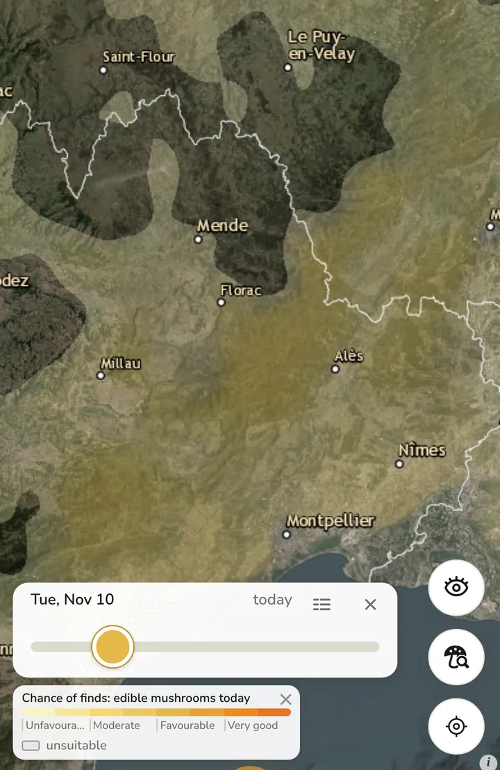
Chance of finds for edible mushrooms in the Cévennes, legend at the bottom left. The legend has four levels: Unfavourable, Moderate, Favourable and Very good. The stronger the orange, the better weather and season suit the species. Grey means unsuitable, such as farmland, towns or water. Where the map shows no colour at all, conditions are weak right now.
- Unfavourable
- Moderate
- Favourable
- Very good
- unsuitable
Plan days ahead
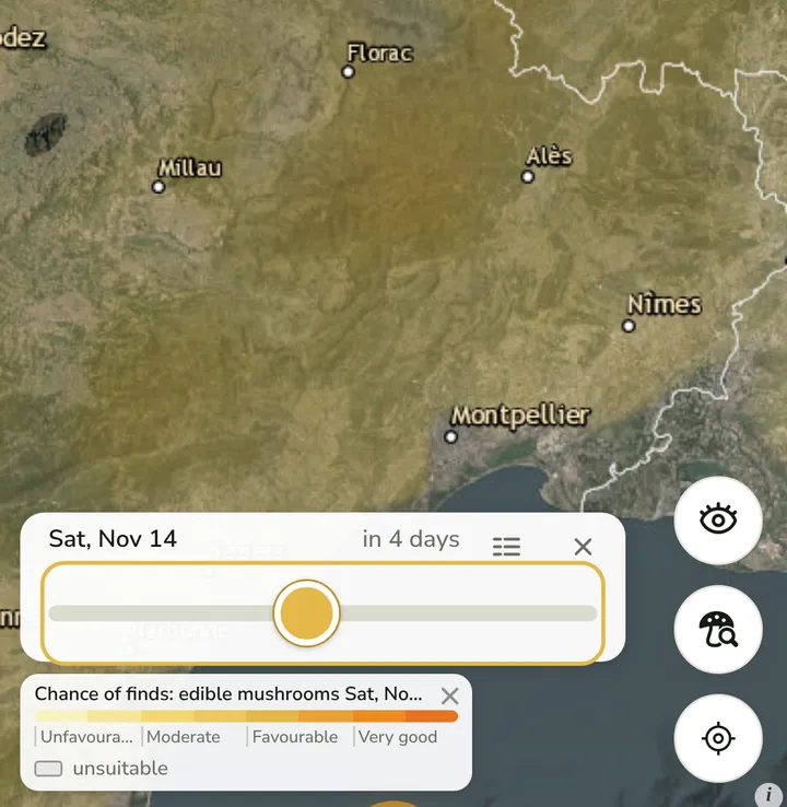
The day slider set to a forecast day four days ahead. The day slider moves between the last three days, today and up to 13 days ahead. For each day the map recalculates whether rain, soil moisture and temperature suit the species.
Zoom in to forest level
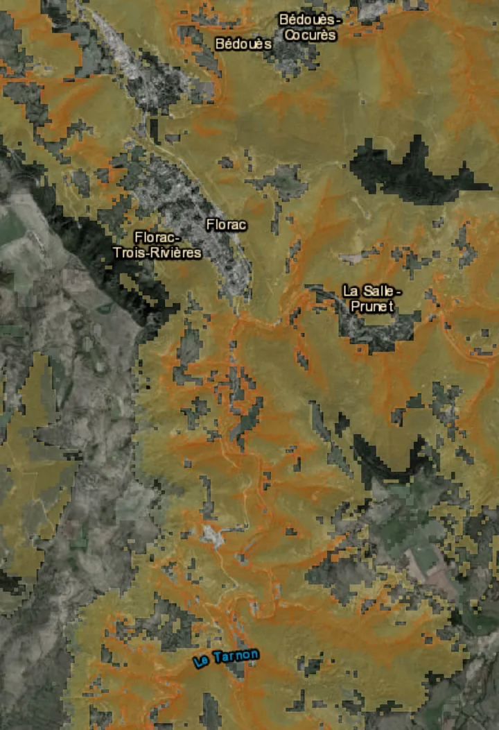
Fine grid near Florac: valleys and wooded slopes glow orange. As you zoom in, the grid gets finer. On the satellite image you can see which slopes, valleys and patches of forest are better than their surroundings. The map shows grid cells, not exact spots.
Look at one spot closely
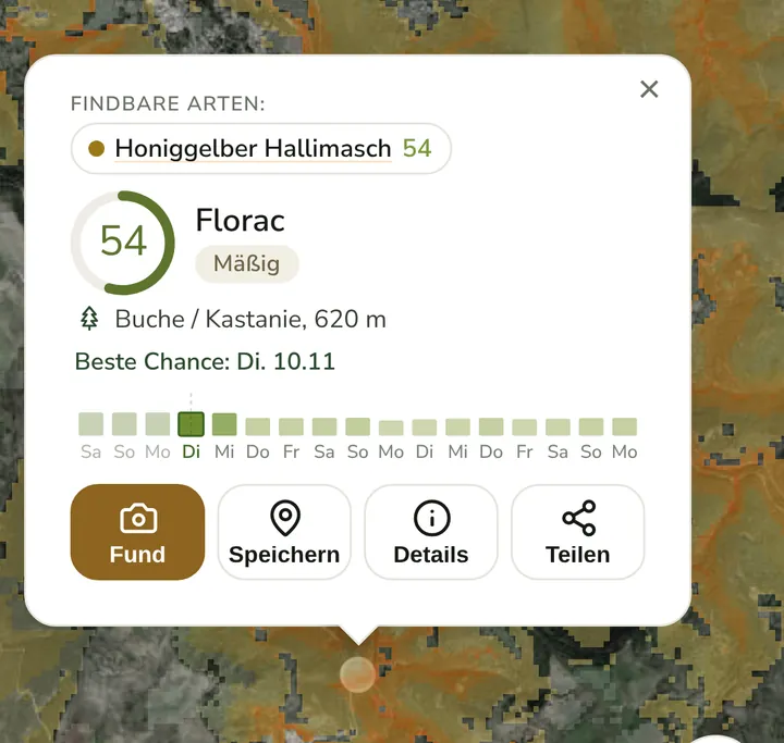
Assessment near Florac: honey fungus at 54 out of 100, level Moderate. A tap on the map opens the assessment for that spot: which species suit it, forest type and elevation, the best day and the trend from three days back to 13 days ahead.


Where the data comes from
The assessment draws on tree species, soil pH, slope, elevation, distance to streams and rivers, clearings and forest fires as well as rainfall, soil moisture and temperature. It is based on open data, including Copernicus (CORINE Land Cover and elevation model), EcoDataCube (tree species and soil pH), Global Forest Change (forest loss) and Open-Meteo (weather). These values are matched with the profile of each species: season, elevation and host trees.
Important: FungiFind does not predict exactly where a mushroom grows, but where conditions are right at the moment. That saves planning time, but it does not replace searching and safe identification on site.
Why FungiFind?
Mushroom growth depends on many factors. Rain alone is not enough. Among other things, these matter:
- Rainfall in recent days: fresh rain moistens forest soil, but too much can be as bad as too little.
- Soil temperature: many edible mushrooms need warm but not hot soil.
- Humidity: dry air slows fruiting body growth.
- Elevation: in the Alps the season shifts compared with lowlands.
- Forest type and tree species: mycorrhizal mushrooms like porcini depend on specific tree partners.
- Season and regional weather trends: each species has its own window.
FungiFind continuously analyses this data and presents it clearly on an interactive map. You can see at a glance which regions are especially promising, whether in the Vienna Woods, Bavarian Forest or Black Forest.
Which mushrooms is FungiFind for?
The app supports foragers searching for many popular edible mushrooms, including:
- Porcini (Boletus edulis and relatives)
- Chanterelles (Cantharellus)
- Morels (Morchella)
- Parasol mushroom (Macrolepiota procera)
- Bay bolete (Boletus badius, Imleria badia)
- Boletes and other pore fungi
- Lion's mane (Hericium erinaceus)
- Wood hedgehog (Hydnum repandum)
- … and many more species
Conditions change with season and region. FungiFind helps with species-specific profiles that consider season, elevation and climate region.
FungiFind compared, different ways to find mushrooms
There are several approaches to good picking areas. None is inherently "better", they complement each other:
| Method | Strengths | Limits |
|---|---|---|
| FungiFind mushroom map | Wide coverage, weather-based, species-specific, updated daily | Needs internet; shows conditions, not individual finds |
| Forums & Facebook groups | Real experiences, local tips, community exchange | Often delayed, subjective, not comprehensive |
| General weather apps | Good forecast for rain and temperature | No link to mushroom species, season or forest soil |
| Your own secret spots | Proven places you know | Only work when the weather fits, otherwise an empty basket |
| Heading out at random | Discovery, fresh air and exercise | Time-consuming, success depends on luck |
Many experienced foragers combine FungiFind for planning with local knowledge on site, the best of both worlds.
Save finds and manage favourite spots
Every forager knows them, the secret spots where mushrooms return year after year.
With FungiFind you can:
- save your own find locations
- add photos
- add notes
- organise your favourite spots
- find previous finds anytime
All data stays private and is visible only to you. You can optionally share individual finds with friends, but FungiFind never publishes your favourite spots.
More features
- Mushroom alert: A push or email when conditions for your species turn favourable at your place.
- Community identification: Upload a photo, read the community’s guesses, ask experts.
- Mushroom forecast for Europe: Find chances, a forecast for more than two weeks and regions with a daily status.
- Mushroom app: Mushroom map, Fungi-Alert and identification by the community in one web app, free to start.
Mushroom knowledge in the integrated blog
Alongside the mushroom map, FungiFind regularly publishes articles about:
- mushroom season and best picking times
- weather and mushroom growth
- scientific insights from mycology
- recipes for fresh edible mushrooms
- foraging tips and identification help
- sustainable mushroom picking
You learn not only where mushrooms can grow, but why. New posts appear several times a week in the FungiFind blog, with sources and links to the species encyclopedia.
For Austria, Germany and all of Europe
Whether Vienna Woods, Bavarian Forest, Black Forest, Alps or Carpathians, FungiFind helps you discover suitable picking areas.
Data is updated continuously and adapted to regional weather. In alpine areas the map considers elevation, seasons start and end later than in lowlands. Nordic and Eastern European regions are covered too.
FungiFind is available in 12 languages (German, English, French, Spanish, Italian, Polish, Czech, Hungarian, Finnish, Swedish, Russian, Romanian), ideal for border regions and holiday foraging.
Search engines like Google find the homepage for terms such as "mushroom map", "porcini weather" or "find mushrooms Austria", the interactive map itself is at fungifind.org/map and one click away from here.
Sustainable foraging, with respect for woodland and nature
Good foragers think about the forest, not just the basket. FungiFind supports sustainable picking: the encyclopedia covers species and season, the blog covers gentle harvesting and identification. The map helps you head out purposefully instead of searching random forests, protecting paths, ground vegetation and quiet zones.
Remember: only pick what you can really use. Often leave young and old fruiting bodies so the fungus can spread. When in doubt, get an expert identification rather than risk it.
FungiFind on your phone, without an app store
FungiFind is a Progressive Web App. Open the mushroom map in your phone browser and add it to your home screen, on iPhone via Share → Add to Home Screen, on Android via the browser menu Install app or Add to home screen. The map is always at hand, almost like a native mushroom app, without a store download.
Privacy comes first
Your personal find locations belong to you.
FungiFind does not publish private spots or share your saved positions with other users. See our privacy policy for details. Operated by LIFECO GmbH in Vienna.
For beginners and experienced foragers
Whether you are just starting or have been foraging for decades, FungiFind helps you improve your chances and discover new areas.
Intuitive use makes the app easy, while rich weather and map data also helps experienced foragers. The encyclopedia aids identification, but never replaces an expert for edible finds.
Frequently asked questions (FAQ)
What is FungiFind?
FungiFind is a free web app with an interactive mushroom map for Europe. It shows where conditions for a find are especially favourable right now.
Is FungiFind free?
Core features (map, encyclopedia, blog) are free. Optional Plus and other plans add more alerts and forecast range, see Pricing.
How does the mushroom forecast work?
Weather data is matched against ecological mushroom profiles. This produces a regional find score on the map, the logic is based on mycology and phenology without publishing the exact algorithm.
Which mushrooms is FungiFind for?
Forecasts for over 4,000 species (many at genus level), including porcini, chanterelle, morel and parasol. The encyclopedia documents over 4,000 species.
In which countries does the map work?
Across Europe, Austria, Germany, Switzerland, the Alps, Scandinavia, Eastern Europe and more.
Do I need to sign up?
No, not for the map and encyclopedia. An account is only needed for personal features.
Are my find locations public?
No. Private find locations remain visible only to you.
How accurate are the forecasts?
They show probabilities for good conditions, not a guarantee of finds. Local factors and on-site identification remain important.
Does FungiFind guarantee edible mushrooms?
No. FungiFind is a planning tool. If unsure about identification, always ask an expert.
How is it different from forums?
Forums share experiences; FungiFind combines live weather with mushroom profiles across regions. Both complement each other.
Do I need internet in the forest?
Yes for the live map. The encyclopedia can be cached offline.
Is there an app?
Yes, as a Progressive Web App, add to your home screen without an app store.
How current is the weather data?
Updated regularly via Open-Meteo, including forecasts for the coming days.
Can I share finds?
Yes, optionally. Private spots stay protected by default.
Is it suitable for beginners?
Yes, intuitive use, encyclopedia and blog. On-site identification is still essential.
Is there a community?
Yes. In the community feed you can share finds, ask questions and follow other foragers. Private spots stay protected.
What is the mushroom quiz trainer?
The quiz trainer is a game inside the app. You practice recognising 187 species from photos and collect points. It does not replace identification in the field.
Discover FungiFind now
Start your next mushroom trip with better planning. Use current mushroom maps, weather data and your personal foraging diary in a modern app built for mushroom hunters.
➡️ Try FungiFind free now